New for today
Other packages & resources:
postmastr: https://slu-opengis.github.io/postmastr/index.html
Open addresses: https://batch.openaddresses.io/
lex_addr <- read_sf("source.geojson")ggplot()+
geom_sf(data = lex) +
geom_sf(data =lex_addr, size = 0.01, alpha = 0.05) +
labs(title = "A map of all addresses in Lexington")+
theme_void()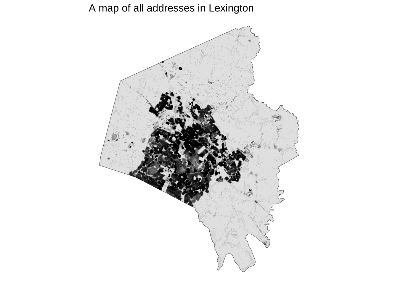
Tidy Geocoder
Info:
https://jessecambon.github.io/tidygeocoder/
tibble(
  UK_landmarks = c(
    "Patterson Office Tower, Lexington, KY",
    "William T Young Library, Lexington, KY",
    "Otis A. Singletary Center for the Arts, Lexington, KY",
    "Rupp Arena, Lexington, Kentucky",
    "Kroger Field, Lexington, Kentucky",
    "Memorial Hall, Lexington, Kentucky"
  )
) |>
  geocode(UK_landmarks) ->
uky_placesuky_places# A tibble: 6 × 3
UK_landmarks lat long
<chr> <dbl> <dbl>
1 Patterson Office Tower, Lexington, KY 38.0 -84.5
2 William T Young Library, Lexington, KY 38.0 -84.5
3 Otis A. Singletary Center for the Arts, Lexington, KY NA NA
4 Rupp Arena, Lexington, Kentucky 38.0 -84.5
5 Kroger Field, Lexington, Kentucky 38.0 -84.5
6 Memorial Hall, Lexington, Kentucky 38.0 -84.5mapview(uk_points)Warning in validateCoords(lng, lat, funcName): Data contains 1 rows with either
missing or invalid lat/lon values and will be ignoredOfficial Sources
Lexington Data Hub
Shape files are downloadable, or:
View Full Details ->
View API Resources ->
Copy the GeoJSON link
lex_bike <- read_sf("https://services1.arcgis.com/Mg7DLdfYcSWIaDnu/arcgis/rest/services/Bicycle_Network/FeatureServer/0/query?outFields=*&where=1%3D1&f=geojson")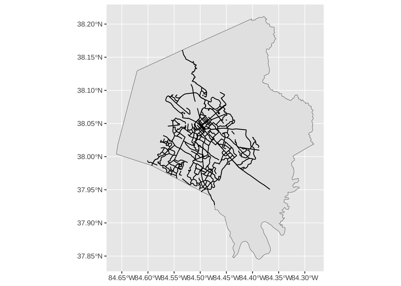
lex_councils <- read_sf("https://services1.arcgis.com/Mg7DLdfYcSWIaDnu/arcgis/rest/services/Council_District_2012/FeatureServer/0/query?outFields=*&where=1%3D1&f=geojson")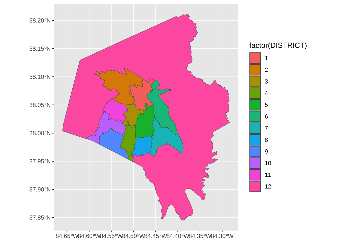
lex_bike |>
  st_intersection(lex_councils) ->
  lex_bike_in_council
Warning: attribute variables are assumed to be spatially constant throughout all
geometries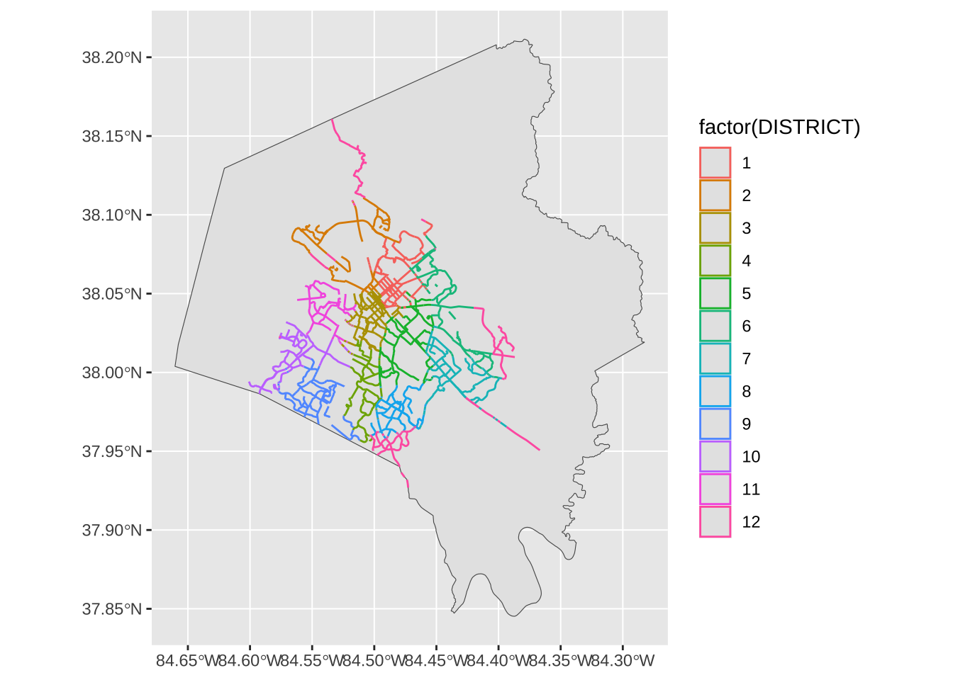
lex_bike |>
  st_intersection(lex_councils) |>
  group_by(DISTRICT) |>
  summarise() |>
  mutate(len = st_length(geometry)) |>
  st_drop_geometry() |>
  arrange(desc(len))
Warning: attribute variables are assumed to be spatially constant throughout all
geometries# A tibble: 12 × 2
DISTRICT len
<int> [m]
1 12 45602.
2 1 44526.
3 3 44427.
4 5 42098.
5 2 40433.
6 6 38747.
7 10 38496.
8 7 38252.
9 9 37219.
10 8 31512.
11 4 29464.
12 11 27430.OSM data
[1] "4wd_only" "abandoned" "abutters" "access" "addr" "addr:city"head(available_tags("shop"))[1] "agrarian" "alcohol" "anime" "antiques" "appliance" "art" opq(bbox = "lexington, kentucky") |>
add_osm_feature(key = "parking") |>
osmdata_sf() -> lex_parkinglex_parking$osm_polygons |>
mapview()lex_parking$osm_polygons |>
st_intersection(lex_councils) |>
group_by(DISTRICT) |>
summarise() |>
mutate(area = st_area(geometry)) |>
st_drop_geometry() |>
arrange(desc(area))Warning: attribute variables are assumed to be spatially constant throughout all
geometries# A tibble: 12 × 2
DISTRICT area
<int> [m^2]
1 3 364701.
2 12 97132.
3 2 50098.
4 4 37441.
5 9 36548.
6 1 29790.
7 7 26475.
8 11 26271.
9 8 15536.
10 5 12143.
11 10 8699.
12 6 8235.Route Data
kroger_route <-osrmRoute(
  kroger_trip$geom[1],
  kroger_trip$geom[2],
osrm.profile = "foot")kroger_routeSimple feature collection with 1 feature and 4 fields
Geometry type: LINESTRING
Dimension: XY
Bounding box: xmin: -84.50409 ymin: 38.03038 xmax: -84.49229 ymax: 38.03877
Geodetic CRS: WGS 84
src dst duration distance geometry
src_dst src dst 22.64833 1.6961 LINESTRING (-84.50409 38.03...mapview(kroger_route)Isochrones
osrmIsochrone(
  loc = kroger_trip$geom[2],
  breaks = seq(0,60, by = 5),
  osrm.profile = "foot"
)->
kroger_walksmapview(kroger_walks, zcol = "isomax")Mashup
opq(bbox = "Lexington, KY") |>
  add_osm_feature(key = "shop", value = "supermarket") |>
  osmdata_sf()->
osm_marketsosm_markets$osm_points |>
st_filter(osm_markets$osm_polygons, .predicate = st_intersects)->
market_overlap_pointsosm_markets$osm_points |>
anti_join(market_overlap_points |> st_drop_geometry()) ->
lex_market_pointsosm_markets$osm_polygons |>
st_centroid() |>
bind_rows(lex_market_points) ->
all_lex_marketWarning in st_centroid.sf(osm_markets$osm_polygons): st_centroid assumes
attributes are constant over geometries of xmapview(all_lex_market, label = "name")Simple feature collection with 12 features and 2 fields
Geometry type: GEOMETRY
Dimension: XY
Bounding box: xmin: -84.59149 ymin: 37.86554 xmax: -84.41769 ymax: 38.18635
Geodetic CRS: WGS 84
First 10 features:
DISTRICT n geometry
1 5 1 POINT (-84.47888 37.9968)
2 7 1 POINT (-84.44418 38.00359)
3 2 2 MULTIPOINT ((-84.52705 38.0...
4 8 2 MULTIPOINT ((-84.47953 37.9...
5 1 3 MULTIPOINT ((-84.48315 38.0...
6 3 3 MULTIPOINT ((-84.51595 38.0...
7 10 3 MULTIPOINT ((-84.55931 38.0...
8 4 4 MULTIPOINT ((-84.49641 37.9...
9 6 4 MULTIPOINT ((-84.46126 38.0...
10 9 4 MULTIPOINT ((-84.55002 37.9...all_lex_market |>
st_join(lex_councils, join = st_covered_by) |>
select(DISTRICT, name) ->
market_by_district
mapview(market_by_district, zcol = "DISTRICT", label = "name")lex |>
st_transform(st_crs(lex_bike)) ->
lex_reprojall_lex_market |>
st_filter(
lex_reproj,
.predicate = st_covered_by
) ->
in_lex_marketsin_lex_markets |>
st_filter(
st_buffer(lex_bike, 100),
.predicate = st_intersects
) -> lex_market_bike
in_lex_markets |>
anti_join(lex_market_bike |>st_drop_geometry()) ->
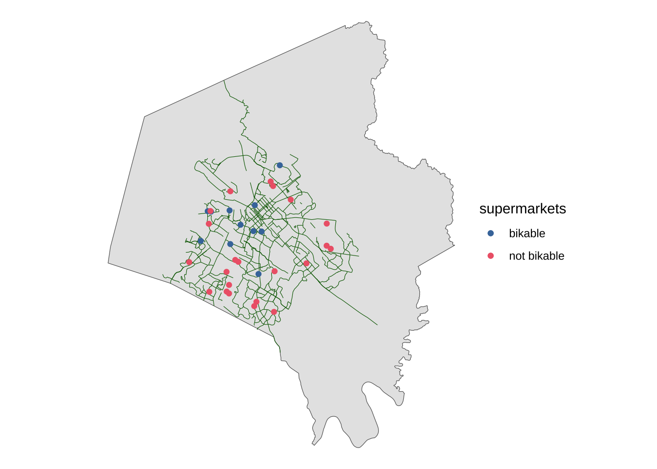
lex_nobikeggplot()+
geom_sf(data = lex_reproj) +
geom_sf(data = lex_bike, color = "darkgreen", linewidth = 0.2)+
geom_sf(data = lex_market_bike, aes(color = "bikable"))+
geom_sf(data = lex_nobike, aes(color = "not bikable"))+
khroma::scale_color_bright(name = "supermarkets")+
theme_void()